Kanheri Caves कान्हेरीगुहा

Kanheri cave complex is situated inside the Sanjay Gandhi National Park in the Borivali region of Mumbai. Before the merge of seven isles, after land reclamation during 19th and 20th century CE, this area was known as the Salsette island. This is one of the most populated island in the world. This island is bounded by Vasai Creek on the north, Ulhas River on the north-east, Thane Creek and Bombay Harbor on the east and by the Arabian Sea on the south and west.
Present high population density has very different reasons altogether however it appears that this island would have been quite populated in the ancient and medieval times. This can be derived from the number of caves, monasteries and shrines excavated on the single hill of Kanheri and similar complexes nearby like that of Jogeshwari, Mahakali and Mandapeshvar. The island would have presented an ideal location for the settlement of the Buddhist community during those times.
The hill in which these caves are excavated was variously known as Krishna-giri, Kanha-giri etc. as evident from inscriptions found here. J Stevenson mentions that the hill was called as Kanha, and later with its Marathi appellation Kanheri. The location of the hill lying over an ancient trade route would have provided an opportunity for the merchant community to come into contact of the Buddhist monks. This resulted in continuous patronage from the merchant guilds for quite a long period.
It is widely accepted that these excavation were started during the Hinayana period. With few exceptions, Kanheri caves are mostly small excavations consisting of a porch or verandah followed by a hall. The hall usually has cells on lateral or back wall. Stone benches are usually provided in the porch and in the cells. J Burgess mentions that stone benches in cells are elsewhere found in Hinayana excavations. The caves were extensively remodeled and sculpted during the Mahayana period.
Kanheri Cave Complex | Saurabh Saxena
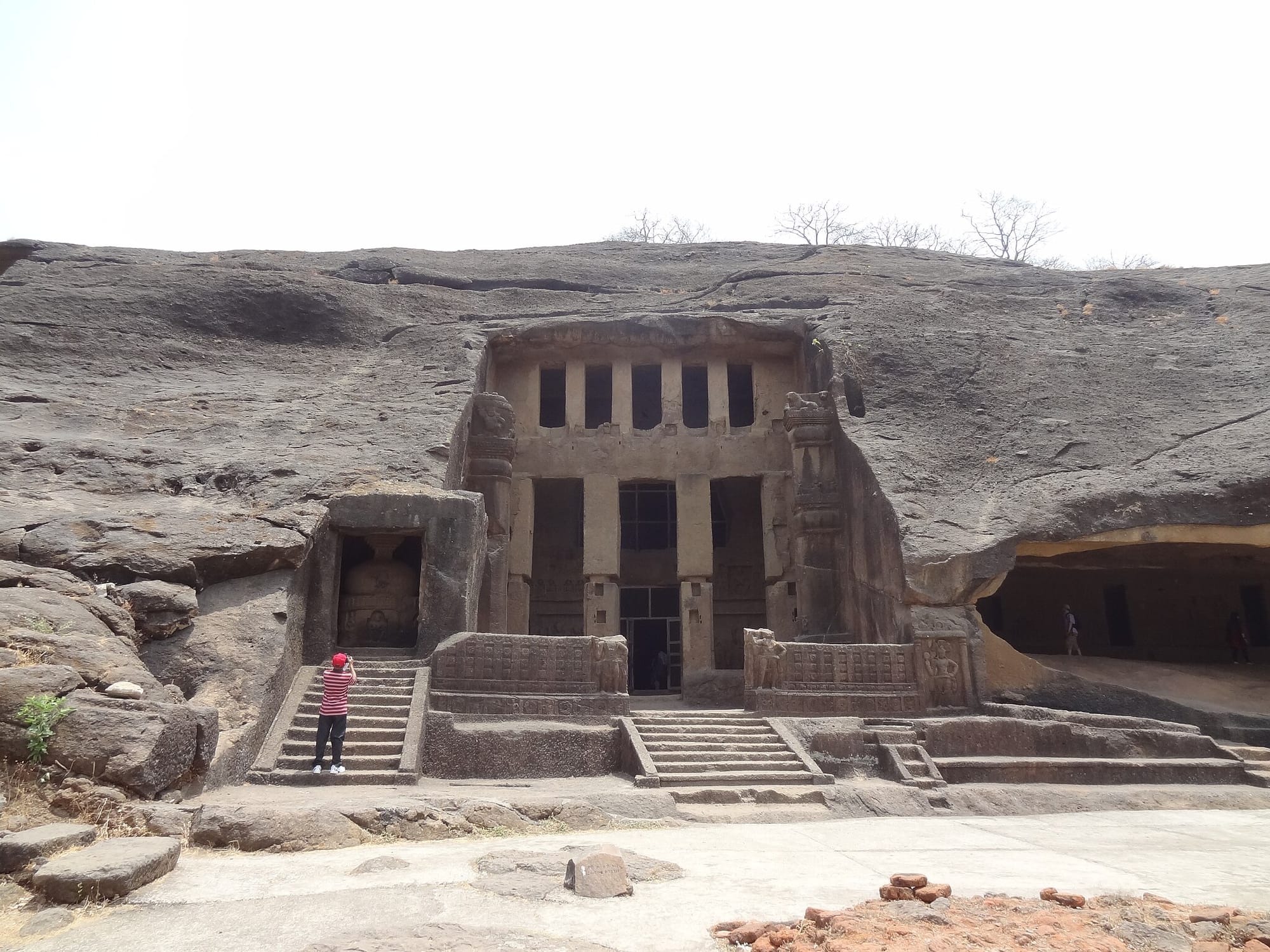
Eddywizz, CC BY-SA 3.0, via Wikimedia Commons
Kanheri (19°13’ N; 72°55’ E), the Kanhasela, Krishnagiri, Kanhagiri of ancient inscriptions, is located north of Mumbai, was a major Buddhist centre. Kanheri is located in the island of Salsette and 6 miles from Thana. The caves are excavated in volcanic breccia, the hills rising at places to 1550’ above mean sea level. Kanheri is credited with the largest number of cave excavations in a single hill. To the west is the Borivili railway station and across the creek is the Arabian Sea.
Kanheri thrived due to its proximity to ancient sea port towns like Sopara (Surparaka, the Supara of Greek; Subara of Arab writers; the ancient capital of northern Konkan), Kalyan a thriving port; Chemula, the Samylla of Greek geographers, Chemula of Silaharas, on the island of Trombay; the other ancient localities nearby were Vasya, perhaps Vasai or Bassein; Sri Staanara or Thana; and Ghodabandar. It is generally believed that Buddhism first arrived in Aparantha (Western India) at Sopara which is very close to Kanheri. The caves were excavated as early as mid 3rd century B.C. and were in occupation right up to 11th century A.D. They were mentioned by early visitors like the Portuguese in the 16th century A.D. and other travellers and voyagers of Europe.
Archaeological Survey of India - Kanheri Caves
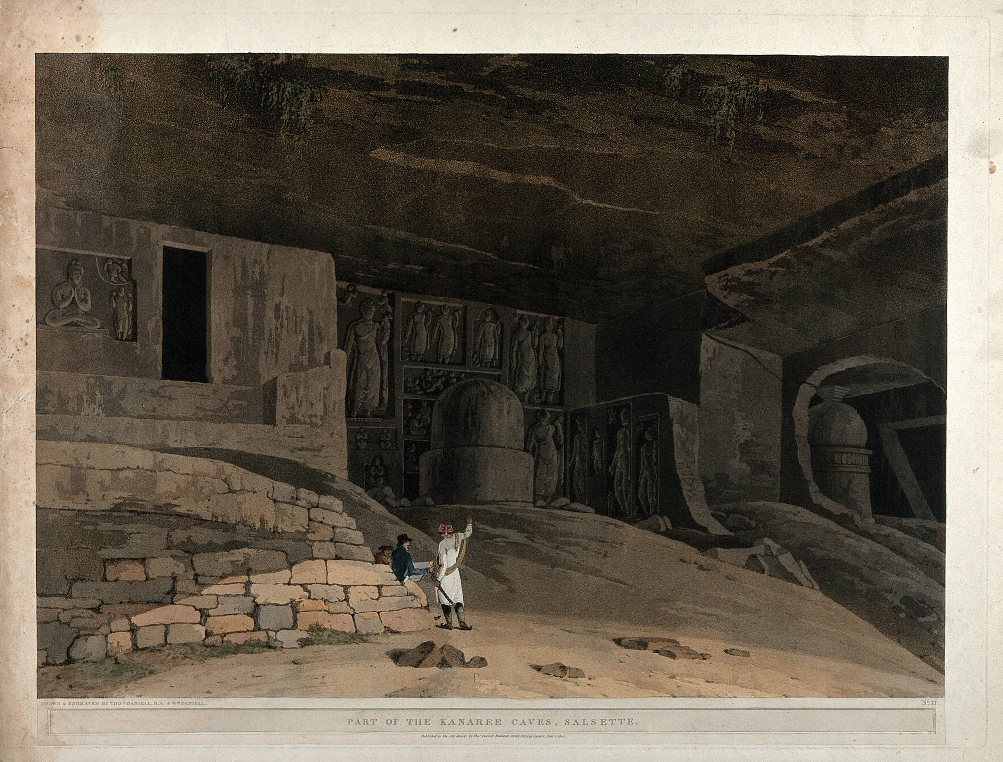
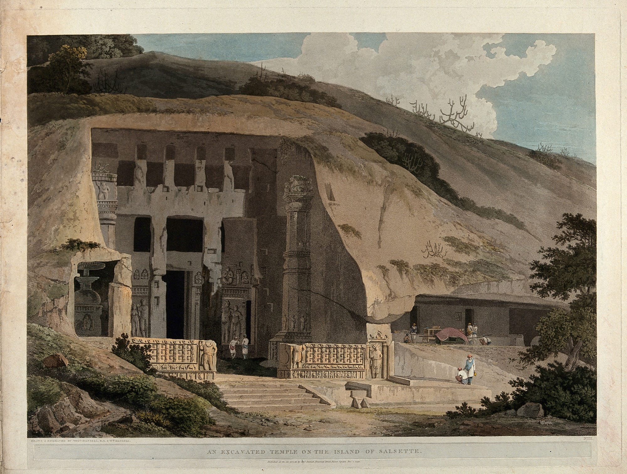
The Kanheri caves on the island of Salsette, near Bombay, Maharashtra. Coloured aquatint by Thomas and William Daniell, 1800. Wellcome Collection. Public Domain Mark. Source: Wellcome Collection.
Daniell, Thomas, 1749-1840.
Date: 1 June 1800
Reference: 27880i
Kanheri’s advantage of location – Various inscriptions at Kanheri refers to gifts of caves, cisterns etc. from the merchants and businessmen hailing from nearby trade centers like Sopara, Kalyan, Nasik, Paithan etc. Antiquity of Sopara, Nasik, Kalyan and Paithan is well established. Kanheri was well within approachable reach to the ancient ports of Sopara, Kalyan and Chaul which would have provided an opportunity for the merchant and traders to come into contact of the Buddhist brotherhood.
Numerous inscriptions at Kanheri refers to gifts and endowments from traders hailing from these ancient sea-ports. Kanheri was also fortunate in being connected to other inland trade centers via road. An ancient trade-route connected it Paithan via Nasik and Junnar, all well known ancient trade centers, as suggested by Dr Pandit. Ancient trade routes connected Sopara to north Indian centers like Ujjain and Bharuch. Such a location for Kanheri would have provided ample advantages in getting patronage from the rich community of traders. It would not be incorrect that this factor would have been instrumental in keeping this complex functional till 11th-12th century CE since its advent.
Kanheri Cave Complex | Saurabh Saxena
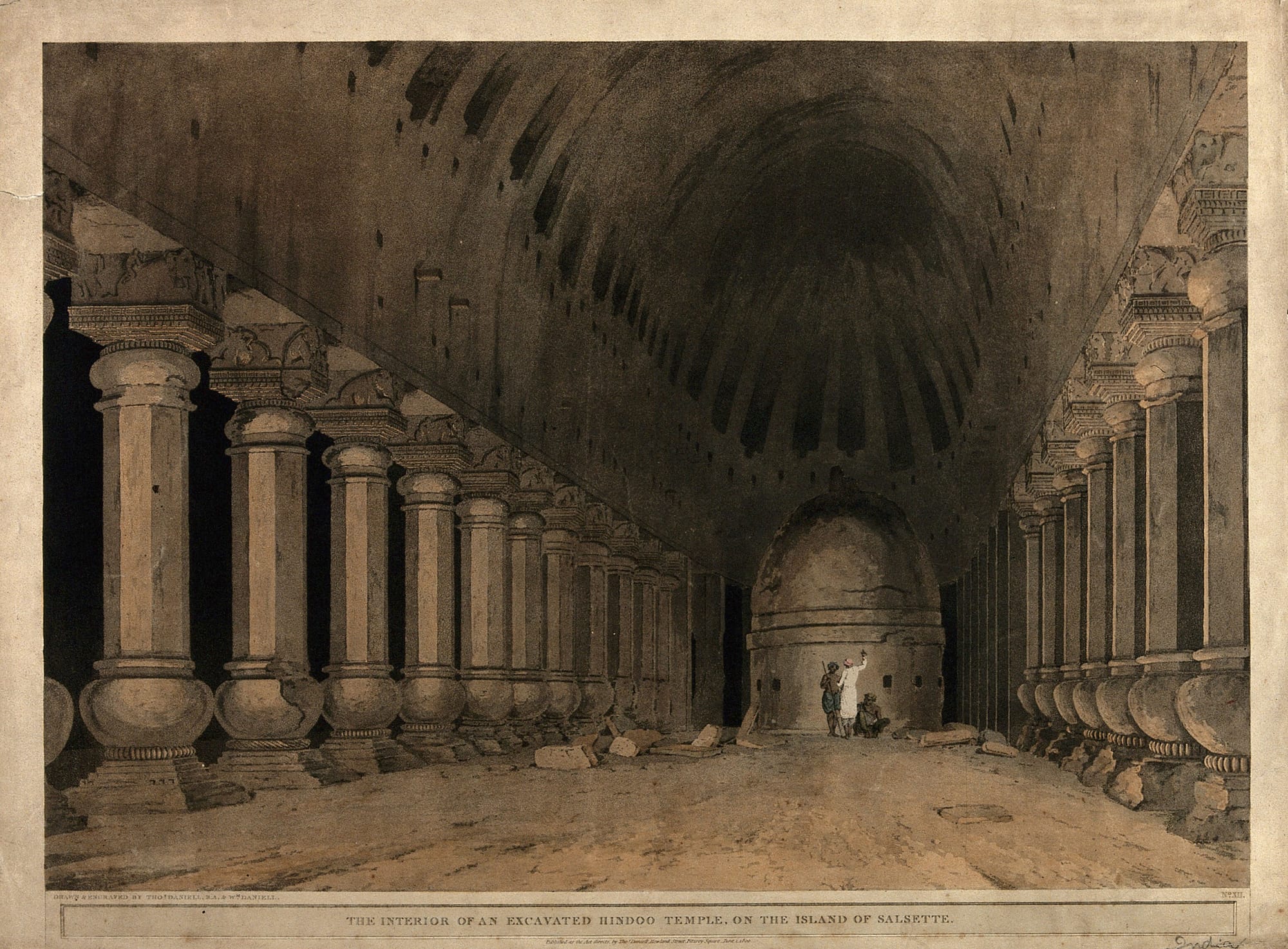
Temple interior with a Buddhist stupa on the island of Salsette, near Bombay, Maharashtra. Coloured aquatint by Thomas and William Daniell, 1800. Wellcome Collection. Public Domain Mark. Source: Wellcome Collection.
Daniell, Thomas, 1749-1840.
Date: 1 June 1800
Reference: 27919i
This article lists down all inscriptions noted by various scholars in the past. These inscriptions were mentioned in the following accounts:
1847, Bird, Historical Researches
1853, Stevenson, Journal of the Bombay Branch of the Royal Asiatic Society vol V
1861, West, Journal of the Bombay Branch of the Royal Asiatic Society vol VI
1883, Buhler, Archaeological Survey of Western India vol V
1911, Luders, A List of Brahmi Inscriptions, Epigraphia Indica vol X
1975, Gokhale, Shobhana, Kanheri Inscriptions. Deccan College, Poona
Kanheri Inscriptions | Saurabh Saxena
This article places the expansion of Buddhist monasteries in the Western Deccan in its wider context, examining how social, political and economic forces might have impacted on the tempo of Buddhist cave cutting.
Donation - For our purposes, donations which were given to the monastic community dwelling within rock cut caves can be divided into two types. The first, funded the building, extension, or decoration of the monastic infrastructure itself, whilst the second provided maintenance, helping to sustain both the monastery and its inhabitants.
Although the nature of epigraphic and structural evidence allow donations toward monastic construction to be identified more readily in the archaeological record, donation toward the maintenance of the monastic community was also intrinsic to the functioning and health of a monastery.
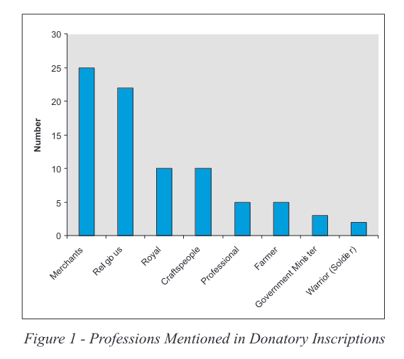
Epigraphic evidence shows that the cutting of caves was mainly funded by groups of lay Buddhists. A number of inscriptions mention the profession' and/or title of the donor who funded monastic expansion. See Figure 1.
A Hiatus in the Cutting of Buddhist Caves in the Western Deccan
Authors: Gethin Rees (PDF)
Year: 2010, Volume: 2, Page/Article: 1, DOI: https://doi.org/10.5334/aa.10209
The Great Chaitya Temple on the island of Salsette, Maharashtra. Coloured aquatint by Thomas and William Daniell, 1799. Wellcome Collection. Public Domain Mark. Source: Wellcome Collection.
Daniell, Thomas, 1749-1840.
Date: 1 December 1799
Reference: 27689i